Historic Landscape
Characterisation
The Gwent Levels
15 Eastern St. Brides
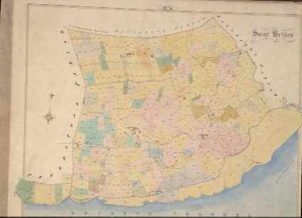
15 Eastern St. Brides character area: complex "irregular
landscape" on higher coastal area.
(Photo: GGAT St Brides CSmap)
Click here for a character
area map
This landscape has formed over a long period of time. The higher coastal areas were probably recolonized in the late eleventh and twelfth centuries. Lower-lying areas inland were subsequently enclosed and drained, probably in the thirteenth/fourteenth centuries. St. Brides Wharf was reclaimed in the eighteenth century.
The medieval Welsh name Llansanffraid Gwynllwg is at least sixteenth century in date.
Key historic landscape characteristics
Diverse landscape: early settlement focus (nr St. Brides Church), irregular
field pattern of small fields and sinuous roads with remnants of roadside
waste, dispersed settlement, seawall including demolished wall, drainage
features include fen-banks, surface ridging (mainly grips, but also rare
"ridge and vurrow")
This landscape occupies higher coastal land at the eastern end of Wentlooge. It merges with area 16 to the west, but the lines of former fen-banks divide it from area 21 to the north. Tredegar Park (now the Duffryn Estate) was created in the northern part of this character area.
This is a very diverse landscape, similar to area 1 (Nash/Goldcliff). To the south of St. Brides church, an oval area defined in the field-boundary pattern probably marks the earliest settlement focus. Elsewhere, the fields are small and irregular and the roads sinuous, formerly with abundant roadside waste (indicated by long narrow fields beside the roads). The settlement pattern is largely dispersed.
A relict sea wall that once ran along Wharf Reen has been demolished, though slight traces of a ramp can be seen in places. The lines of sinuous fen-banks mark the limit of this enclosed/drained landscape and the former open moors in the lower-lying back-fens. Very fine examples of surface ridging; mainly grips, but includes some "ridge and vurrow" that is otherwise very rare in Wentlooge.
Parts of this landscape have a relatively wooded feel, with numerous mature trees in the hedges. Other hedges are typically scrubby.
The integrity and coherence of the area are high. This is an area of
landscape typical of the higher coastal lands throughout the Levels. The
early settlement site at St. Brides, lines of former fen-banks, and eighteenth
century reclamation of St. Brides Wharf, are components of a complex and
diverse landscape, which has a high group value. There are some fine areas
of surface ridging, and traces of former roadside waste.